
After spending 48 hours in Somalia’s war-torn capital, Mogadishu [see post: 48 Hours in Mogadishu], I was off to Addis Ababa via Nairobi to pick up a visa and meet the rest of the Untamed Borders group.
I arrived at Addis Ababa Bole International Airport in the evening of Monday, April 2, 2018. Although tourist visas are available on arrival at Bole International Airport in Addis Ababa for U.S. and E.U. passport holders, I chose to obtain an e-Visa for the same cost prior to departing for Ethiopia. The process is super easy and quick. Note: Single-entry tourist e-Visas are valid for 30 or 90 days, starting from the date of arrival in Ethiopia.
Addis Ababa
The next morning was “Day 1” of the Horn of Africa – Ethiopia and Somaliland itinerary. The optional tour of the city began with a stop at the Embassy of the Republic of Somaliland. Given that Somaliland is not an internationally recognized country, but a self-declared state, there are very few countries in the world where you can obtain a Somaliland visa. After applying for a visa, we set out to explore the city.
First stop: Merkato – the largest open-air market in Africa. Crowded chaos. We wandered aimlessly around the market before leaving for lunch.


After a traditional Ethiopian lunch, we walked over to the National Museum of Ethiopia to meet 3.2-million-year-old Lucy, or in my case, her plaster replica.


From the museum, we stopped by the Holy Trinity Cathedral before driving up Entoto Hill for a panoramic view of Addis Ababa.


Erta Ale
Early the next morning we departed Addis Ababa and began the journey to Erta Ale. We arrived at Alula Aba Nega Airport in Mek’ele and headed to the city center to gear up.

In a three vehicle convoy, we hit the road towards the Danakil Depression – the hottest inhabited place on Earth.

And yes, it was hot; it reached 50 Celsius (or 122 Fahrenheit) that day. The next three days would prove to be physically and mentally challenging.

We spent the entire day confined to a vehicle. Relaxing? Not quite. Each car was jam-packed with five bodies plus gear. Squished together, we spent the entire day trying not to fall onto each other as the vehicle shook uncontrollably crossing unpaved roads and volcanic terrain.


Along the way, we collected our police guards and later our Afar militia escorts. Located near the Ethiopia-Eritrea border, the Danakil Depression is one of the most remote areas of the Afar region. Not only is the region one of the hottest on Earth, but it is also one of the most geologically active. Situated in the Danakil Depression, Erta Ale volcano (locally known as “the gateway to hell”) holds one of the only six permanent lava lakes in the world, attracting adventurists from around the world. Given its location, the Danakil Depression remains an area that comes with a measure of risk. The region has seen violence in the past. In 2012, five European tourists were killed and four others abducted by gunmen on the edge of Erta Ale’s crater. Even though all tourist groups are now accompanied by armed escorts, your safety is not guaranteed. In December 2017, I received an email from Untamed Borders discussing the murder of a German tourist who was visiting the volcano just days before. Tour operators monitor the situation closely, but it is important to note that the security situation can change without notice.

In the late afternoon, we finally reached base camp. I thought the day would never end.


We waited until nightfall before beginning the multi-hour trek to Erta Ale’s rim (I read that the distance is anywhere from 10 to 14 kilometers or about 6.2 to 8.7 miles). I was ready to pass out; little did I know, my “day” was nowhere near over. It took me about five hours to reach the top of the volcano – five hours of hiking up rough ground in complete darkness; five hours of screaming at my body not give out on me; five hours of questioning my decision to include the Danakil Depression in my itinerary. I will mention, this hike is advertised as a three hour trek. Yeah. Time to work on my fitness or I will suffer hiking up Mount Nyiragongo in November.


Reaching the top, I was more excited about sleeping than I was about walking over to the crater. Standing at the edge, I felt disappointed. Actually, the word “disappointed” does not do justice. Smoke filled the entire crater, completely obstructing the view of the lava lake below. Just as quickly as I walked over to the crater, I walked back to “camp”.


It was past midnight the next day. Luckily, I was so exhausted that I could fall asleep anywhere. Which was ideal, because I do not imagine that I would fall asleep in such conditions otherwise. No tent. No cover. Just a plastic tarp. And rain.


Not even three hours later, we were woken up to begin the hike down. My feet were swollen and my body was running on empty. It was still dark out. Staring down at where I pointed my flashlight, I felt like a zombie. My brain was completely shut off while climbing down the volcano. I only looked up when the sun finally started to rise.


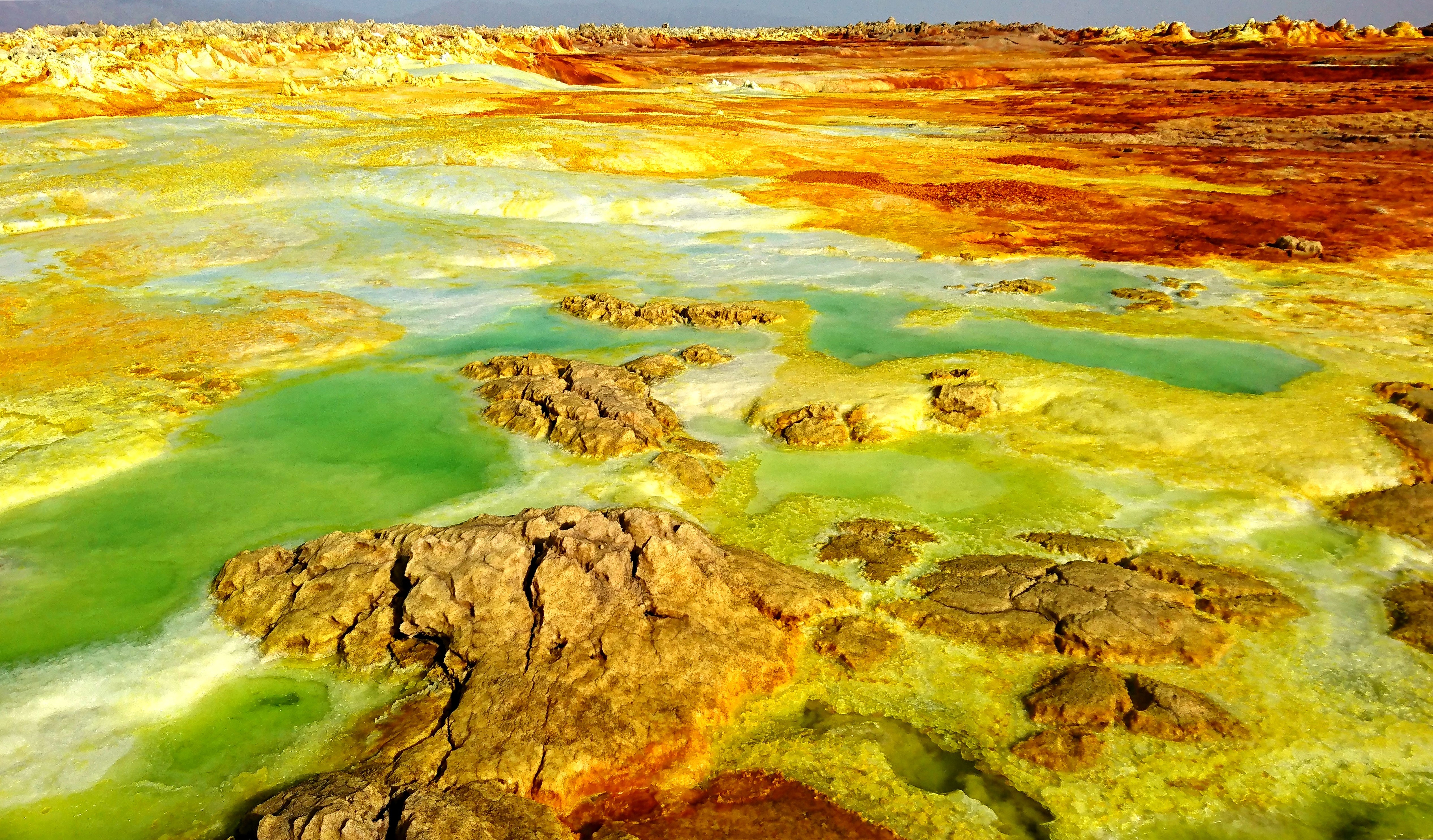
Dallol
From base camp, we spent most of the day driving to Hamed Ela – a village in the Dallol area of the Afar region. The plan was to witness the life of the salt mining Afar nomads that live in this otherwise inhospitable climate. Unfortunately, it was Friday. Not only was this a day off for Muslims, but it was also Good Friday, a holiday for Christians. The salt flats were completed deserted. We did not get a chance to see the Afar miners chop salt from the earth or see the camel caravans march through the salt flats.


Instead, we watched the sun set before driving to a nearby military camp for dinner and sleep. Let me tell you – the tarp nap was much more comfortable than this night. Imagine sleeping outside at a military camp in excruciating heat. It was not fun.


It was a long night. I could not stay asleep in such conditions. Luckily, nobody else could either. We packed up and headed out to explore Dallol’s otherworldly landscape early that morning.


Every shade of green, yellow, and orange covers the unique setting of the lowest place in the Danakil Depression. Acid pools, salt deposits, rock formations, sulphur and salt lakes – a sight like none other.


Also, an experience like no other – you can literally walk anywhere you please. Just do not fall in. This is not Yellowstone National Park, there are no walkways or barriers.


After an hour or so, we climbed down and visited the nearby salt canyons before beginning the journey back to Mek’ele. [see post: Ancient Africa: Mek’ele to Axum]


